Where a Controlled Water is deemed to be at potential risk from contamination, be it either a surface water course or groundwater, a Quantitative Groundwater Risk Assessment (QGRA) may be required. Commonly, this is needed to satisfy the requirements of the Environment Agency as a Consultee on a Planning Condition, though assessments may also be undertaken for other regulatory compliance and corporate due diligence purposes.
Groundwater risk assessments can vary from a simple Level 1 Assessment, comparing groundwater concentrations against drinking water or EQS standards, through to more detailed computer based modelling, taking into account fate and transport properties, aquifer properties and contaminant degradation. The purpose of a Groundwater Risk Assessment is essentially to assess what level of contaminant could safely be left in-situ without detriment to a defined receptor and hence is generally used to derive clean up levels during the remediation phase or to demonstrate that a certain level of contaminant is of no cause for concern.
Applied Geology has experience in undertaking groundwater risk assessments in a broad range of situations. This experience has helped many of our clients reduce remedial costs which would have previously been associated with a site by a combination of technical expertise, close regulatory liaison and commercial awareness. Whilst the additional costs associated with a more detailed QGRA may be significant in some cases, these are almost always outweighed by potential financial savings and/or programme improvements.
CASE STUDY
Case Study 1
Following a detailed, phased investigation at a former garage site in Kenilworth, a source of hydrocarbons, identified in both soil and groundwater, was deemed to present a potential risk to a local groundwater resource. A QGRA was undertaken based on the hydrocarbon fractions present and a site specific level for total petroleum hydrocarbons (TPH) was established based on the identified hydrocarbon composition that was protective of Controlled Waters. Following detailed liaison with the Environment Agency, this became the clean up level that was to be achieved during and after the remediation of the site. Remediation was achieved by a combination of a multi phase vacuum extraction system and local excavation. Applied Geology monitored the works, liaised with the regulatory bodies and, finally, produced a validation report on the works undertaken.
Case Study 2
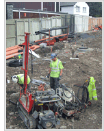
A detailed combined geotechnical and geoenvironmental investigation was undertaken on the site of a former motor manufacturing works in East London. Desk studies revealed that the area of the site in question had formerly been utilised for the tipping of foundry sands from the manufacturing process over a period of many decades. Geological maps indicated that the underlying natural geology would comprise soft alluvial clays with bands of peat, underlain by flood plain gravels with solid strata of the London Clay and/or Woolwich & Reading Beds at depth. The actual investigation indicated the presence of up to 5m of foundry sands and ash, with both background levels and hotspots of more significant hydrocarbon and solvent impact, overlying the anticipated geology. Nearby surface water courses and the underlying flood plain gravels were defined as the receptors of concern by the Environment Agency. Geotechnical options for the site, which was to be developed with industrial warehousing, were restricted due to the presence of deep Made Ground and weak natural strata and were effectively limited to a piled solution with near surface improvement of the Made Ground for external yards and car parking. Potential existed for both contamination of the surface receptor by horizontal migration and the underlying minor aquifer via preferential migration pathways adjacent to piles.
Following detailed groundwater risk assessment, further more detailed investigation, ongoing monitoring and a period liaison with the Environment Agency, it was concluded that the identified hotspots were of smaller magnitude than had originally been suspected and that the background concentrations of hydrocarbons and solvents did not pose an unacceptable risk to the controlled waters. Furthermore, the groundwater sampling and testing suggested that reductive dechlorination of the solvents was occurring based on the presence of daughter products and chemical conditions, which provided further supporting evidence that the ongoing risk was reducing.
Following a period of agreed monitored natural attenuation exceeding 18 months and a detailed construction plan, incorporating measures to mitigate vertical contamination migration, the scheme was approved by the Environment Agency and no further site specific remediation was required.
Case Study 3
 Applied Geology was commissioned to undertake a geotechnical appraisal for extensions to a famous hotel overlooking Lake Windermere. Due to access problems the investigation initially comprised a series of shallow boreholes using a dynamic continuous sampling (DCS) rig unit. This work suggested a very variable depth to rock head, probably comprising infilled channels. This work was followed by a series of deep cable tool boreholes in accessible areas to provide data on a raft design and a possible pile design. During the initial work one of the DCS boreholes encountered hydrocarbon impacted soil and groundwater. Following discussions with hotel operatives it was gleaned that this was the area of a former oil tank associated with the boiler house which had been de-commissioned a few years earlier.
Due to the proximity of Lake Windermere and the presence of a direct pathway via granular soils (the infill to the channels) as well as the possible impact on the fabric occupants of the new structure it was agreed that further work and assessment was needed. To this end a further series of DCS boreholes were sunk to identify the shape of the plume and the concentrations of Total Petroleum Hydrocarbon present within it, and to assess the extent of any remediation, if any, that was needed to break the pollutant linkages. Groundwater samples were subsequently obtained from probes and tested. The plume was confirmed a risk and hence remediation was required and an in-situ system was agreed. This comprised the injection on a grid basis of bioremediation material (comprising of Oxygen Release Compound (ORC) Advanced and RegenOx), installed using a DCS rig unit. A specification from the bioremediation material supplier was followed and a total of ten injection points were used at 3m spacings across the affected area to inject the calculated amount of ORC. The ORC was injected to accelerate the natural process of clean up within a hydrocarbon impacted groundwater.
Three further boreholes were drilled and instrumented to allow monitoring throughout the remediation phase. Groundwater samples were abstracted from each of these boreholes for testing prior to injection of the bioremediation materials to give baseline levels for the presence of pH, Dissolved Oxygen, Oxidation/Reduction potential, temperature, conductivity, Chemical Oxidant, Soil Oxidant Demand, VOC’s, Alkalinity as CaCO3, Major Anions, Major Cations (Metals) and Hexavalent Chromium.
The boreholes were then monitored at intervals after the injection at 1 week, 2 weeks and 3 weeks for the presence of pH, Dissolved Oxygen, Oxidation/Reduction potential, temperature and conductivity.
The site was then left until three months after injection when a further return monitoring visit was undertaken to assess new samples and compare them to the baseline levels prior to the injection of bioremediation materials. The results of the groundwater testing showed that there were no longer any hydrocarbons present with results of less than 10ug/l being recorded in each of the boreholes.